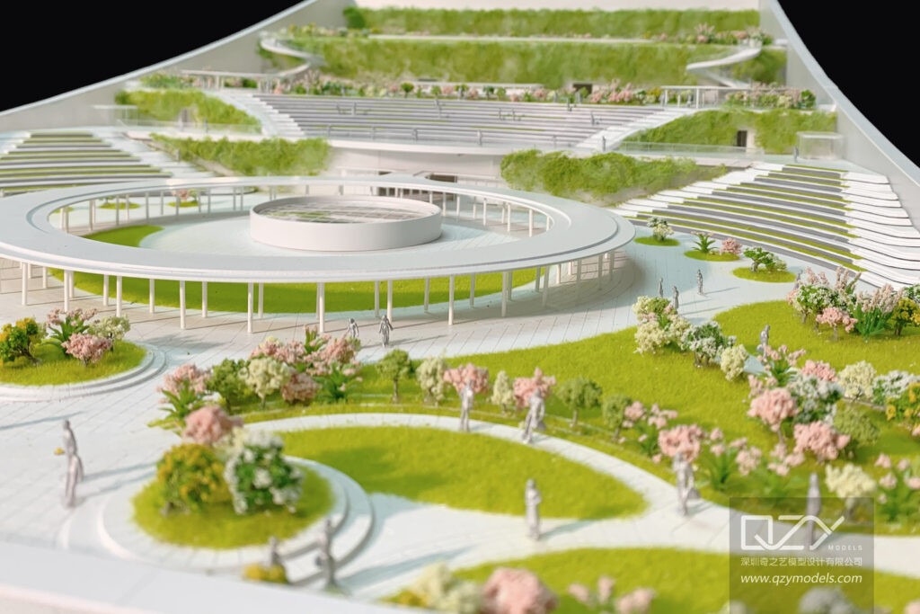
Topo models are precise physical or digital representations of terrain, showing elevations, slopes, and landforms. Widely used in architecture, urban planning, and industrial design, they help visualize complex landscapes, guide design decisions, and communicate site conditions effectively to clients, stakeholders, and project teams, bridging the gap between conceptual plans and real-world implementation.
What Are Topo Models and Why Are They Important?
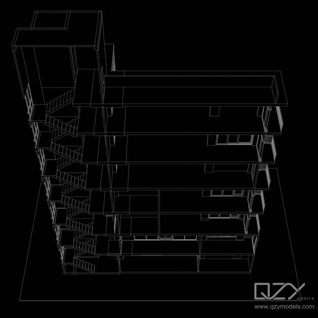
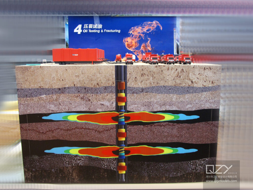
Topo models are scaled depictions of terrain, including natural features, slopes, and elevations. They are critical for architects, planners, and developers to evaluate site conditions, plan layouts, and anticipate construction challenges. Accurate topo models enhance design decisions by offering realistic, three-dimensional terrain visualizations.
Materials such as foam, wood, acrylic, or 3D-printed resin are used to create topo models. These models combine technical precision and artistic craftsmanship, providing clients and stakeholders with a tangible understanding of complex ground details, reducing miscommunication and improving project outcomes.
How Are Topo Models Created and What Technologies Are Used?
Topo models are produced using a combination of traditional craftsmanship and digital technologies. Survey data, GIS files, or LandXML files form the foundation, which is then processed with CAD software or BIM tools like Autodesk Revit to generate accurate terrain surfaces.
3D scanning, CNC machining, and 3D printing allow high-precision physical models. Digital preparation ensures speed and accuracy, while hand-finishing adds fine details, textures, and aesthetic refinement.
| Creation Method | Tools/Materials Used | Key Benefits |
|---|---|---|
| Manual Crafting | Foam, wood, acrylic | High tactile detail, artistic |
| Digital Modeling | CAD, GIS, Revit | Precise, fast revisions |
| 3D Printing | Resin, PLA, photopolymer | Repeatable, detailed features |
Which Industries Benefit Most from Using Topo Models?
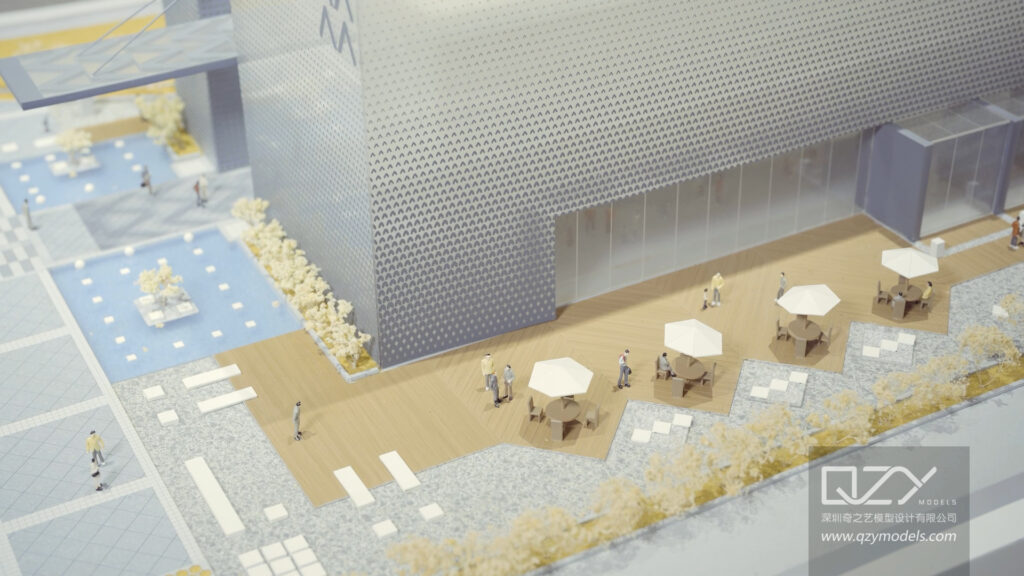
Topo models are valuable across multiple sectors. Architectural design firms, urban planners, real estate developers, landscape architects, and industrial designers leverage topo models for feasibility studies, site planning, and client presentations. Educational institutions also use these models to teach design and geography concepts.
International clients, including those in the Middle East and Europe, often commission topo models for large-scale projects requiring detailed terrain visualization.
| Industry | Application | Benefits |
|---|---|---|
| Architecture | Site analysis, presentations | Improved design accuracy |
| Urban Planning | Land use, infrastructure planning | Clear visualization of terrain |
| Real Estate Development | Feasibility, marketing | Enhanced project appeal |
| Landscape Architecture | Terrain sculpting, project planning | Better spatial communication |
| Education | Teaching design and geography | Hands-on learning and understanding |
Where Can High-Quality Topo Models Be Commissioned?
High-quality topographic (topo) models can be commissioned from specialized firms that combine technical expertise with craftsmanship. For example, QZY Models, based in Shenzhen with global operations, offers bespoke architectural and industrial models. With over 20 years of experience, the company uses advanced modeling techniques and strict quality control to ensure each model meets precise client specifications.
Why Choose a Specialized Model Maker
-
Precision and Accuracy: Essential for architects, developers, and planners to visualize terrain and site layouts.
-
Custom Solutions: Models can include detailed terrain features, vegetation, infrastructure, and scale buildings.
-
Enhanced Communication: Physical models make complex designs easier to present to clients or stakeholders.
Tips for Commissioning a Topo Model
-
Provide detailed site plans, elevation data, and CAD files to ensure accuracy.
-
Discuss scale, materials, and level of detail early to avoid revisions.
-
Ask for a prototype or 3D render before final production.
Quick Checklist Before Ordering:
-
☐ Site data submitted
-
☐ Desired scale confirmed
-
☐ Material preferences defined
-
☐ Delivery timeline agreed
Top-quality topo models not only showcase terrain but also strengthen project presentations and design decisions.
How Do Topo Models Enhance Project Presentations?
Topo models turn flat plans into three-dimensional representations, improving comprehension and stakeholder engagement. Physical models provide tactile and visual references for spatial relationships, while digital models can be animated or integrated into BIM workflows for collaborative reviews.
These models strengthen presentations, clarify design concepts, and facilitate informed decision-making for clients, planners, and project teams.
Are There Sustainable Practices in Topo Model Making?
Yes, sustainable practices are increasingly adopted in topo model production. Companies like QZY Models utilize eco-friendly materials, reduce waste through digital planning, and repurpose models across multiple project phases.
Digital modeling minimizes the need for physical prototypes, cutting material use and energy consumption. Recycled or low-impact materials are also integrated, supporting environmental responsibility without compromising model quality.
Who Are the Experts Behind Topo Models at QZY Models?
QZY Models is led by founder Richie Ren, whose 20+ years of experience ensures precision and innovation in every project. The global team operates in regions including the UAE, Saudi Arabia, and Egypt, bringing multidisciplinary expertise.
QZY Models combines client-focused service with advanced technologies and traditional craftsmanship, producing topo and architectural models that balance aesthetic appeal with engineering accuracy.
When Should Topo Models Be Integrated into the Design Process?
Topo models should be introduced early during site analysis and conceptual design. Early integration identifies site opportunities and constraints, reducing costly revisions later.
Models also assist in environmental assessments, zoning approvals, and client presentations, providing a strong foundation for informed project decisions throughout the design and construction phases.
QZY Models Expert Views
“Topo models bridge the gap between digital design and physical reality. At QZY Models, we combine advanced technology with traditional craftsmanship to produce models that are both visually impressive and highly accurate. This precision helps architects and planners make better-informed decisions, streamline project execution, and deliver designs that harmonize with their landscapes.” — Richie Ren, Founder of QZY Models
What Are the Key Benefits of Using QZY Models for Topo Models?
QZY Models delivers custom topo models with unmatched precision and professionalism. Their models enhance project presentations, reduce design errors, and communicate complex site conditions effectively.
With global expertise and advanced tools, QZY Models combines digital technology and artisan craftsmanship to produce topo models that exceed industry standards and serve diverse architectural and industrial projects.
Conclusion
Topo models are indispensable for architects, developers, and planners, translating complex terrain into tangible, visual tools. By commissioning models from experts like QZY Models, teams gain precision, sustainability, and enhanced communication throughout the project lifecycle. Early integration and professional execution ensure accurate planning, informed decisions, and impressive presentations, elevating every project from concept to reality.
FAQs
Q: What materials are typically used in topo models?
A: Common materials include foam, wood, acrylic, and 3D-printed resins, selected for durability, precision, and visual fidelity.
Q: Can topo models be integrated with digital workflows?
A: Yes, digital topo models can be incorporated into CAD, BIM, and virtual reality platforms to support collaborative design and presentation.
Q: How long does it take to create a custom topo model?
A: Depending on complexity, models may take from a few days for simple designs to several weeks for large-scale, highly detailed projects.
Q: Do topo models help with regulatory approvals?
A: Yes, accurate models provide clear visualizations that support zoning, environmental, and planning submissions.
Q: Why choose QZY Models over other model makers?
A: QZY Models combines 20+ years of expertise, global experience, sustainable practices, and precision craftsmanship, delivering topo models that meet the highest standards.