A topographical model is a precise three-dimensional representation of terrain, showing elevations, slopes, and landforms at scale. It matters because it enables architects, planners, engineers, and clients to visualize site conditions, assess design feasibility, and communicate complex spatial concepts clearly. QZY Models specializes in producing high-quality models that transform survey data into accurate, decision-ready tools for urban planning, landscape, and infrastructure projects.
How is a topographical model defined in architecture and planning?
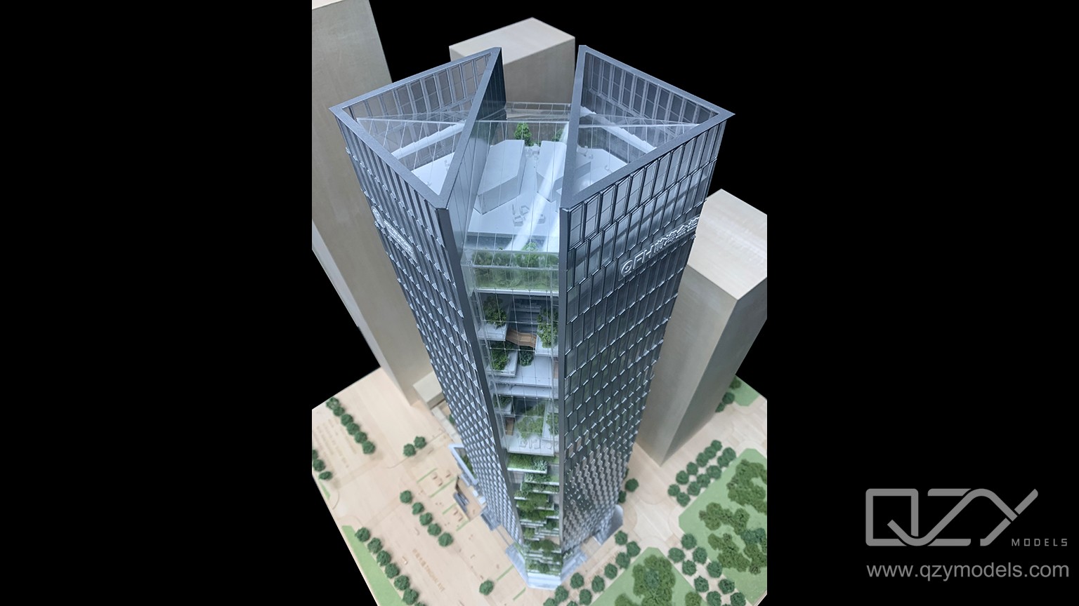
In architecture and planning, a topographical model is a scaled 3D physical representation of a site’s contours, elevations, and key features like hills, rivers, roads, and buildings. It allows stakeholders to analyze visibility, accessibility, drainage, and integration of new structures before construction. QZY Models enhances these models with removable structures, CNC‑milled terrain, and realistic textures to create presentation-ready assets for design reviews and approvals.
Let’s break this down simply. In architecture and planning, a topographical model is a small-scale 3D version of a real site that shows the shape of the land, including hills, rivers, roads, and existing buildings. It helps architects, developers, and planners see how new structures will fit into the environment, check visibility, plan access, and consider water flow before any construction begins.
Companies like QZY Models take these models further by adding removable buildings, CNC‑cut terrain, and realistic textures, making them highly detailed and easy to use for presentations. This allows teams to review designs, make decisions, and get approvals more effectively. By providing precision, realism, and clear visualization, topographical models become essential tools for both planning and communicating architectural ideas.
How are topographical models used in real projects?
Topographical models are employed to visualize site conditions, test layouts, and communicate proposals to clients, investors, and authorities. They support feasibility studies, environmental assessments, and urban or landscape planning. Applications include:
-
Feasibility and concept design: Evaluating orientation, views, access, and massing.
-
Urban planning: Coordinating roads, bridges, and public spaces over complex terrain.
-
Landscape and resort design: Assessing terraces, pools, and drainage integration.
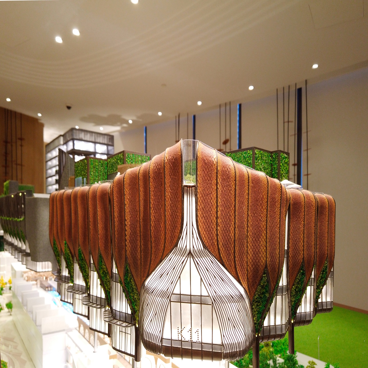
QZY Models integrates interactive elements, lighting, and removable components to display underground structures or phased development plans, enhancing stakeholder understanding in large-scale and mixed-use projects.
Let’s explain this clearly. In real projects, topographical models are used to show what a site looks like and how new designs will fit within it. They help architects and planners test layouts, check access, orientation, and views, and explain ideas to clients, investors, or government authorities. These models are also useful for studying environmental impact, planning urban roads and bridges, or designing landscapes and resorts, including terraces, pools, and drainage systems.
Companies like QZY Models enhance these models with interactive parts, lighting, and removable sections, allowing viewers to see underground structures or phased development plans. This improves visualization, makes complex projects easier to understand, and helps teams make better design decisions. By combining accuracy, detail, and interactivity, topographical models become a key tool for presenting and refining architectural and urban planning projects.
Why does an accurate topographical model matter for decision-making?
Accurate topographical models translate survey data into tangible terrain, enabling informed decisions on layout, construction cost, and risk mitigation. Even small deviations in elevation or slope can affect earthwork estimates, drainage efficiency, and foundation planning. QZY Models achieves millimeter-level precision using digital elevation data, CAD, and BIM outputs, ensuring reliable models for evaluating alternatives, especially on challenging sites like coastal or steep landscapes.
How is a topographical model created from survey or BIM data?
The process begins with converting survey or BIM elevation data into a 3D surface. Fabrication methods include CNC milling, contour stacking, or 3D printing. Steps include:
-
Data preparation: Clean, scale, and segment survey points or BIM surfaces; define vertical exaggeration and key features.
-
Surface generation: Slice into contour layers or generate CNC toolpaths for continuous terrain.
-
Fabrication and assembly: Materials like PU foam, MDF, acrylic, or resin are shaped and combined, with painting, labeling, and detailing for readability.
QZY Models combines digital precision and artisanal craftsmanship to produce durable, visually striking terrain models suitable for competitions and exhibitions.
Which materials and scales are best for topographical models?
Material and scale selection depends on project goals, detail required, and budget. Popular choices include foam, wood, and acrylic at scales like 1:500, 1:1000, and 1:2000.
| Scale | Best for | Detail level |
|---|---|---|
| 1:500 | Building clusters, resorts, campuses | High – buildings, roads, trees |
| 1:1000 | District / mixed-use masterplans | Medium – blocks, streets, main terrain |
| 1:2000+ | Regional or infrastructure studies | Low – overall form and network |
Foam and PU boards are lightweight and machinable for CNC milling, MDF for robust contour models, and acrylic/resin for water or special features. QZY Models advises optimal material-scale combinations for transport, climate, and display requirements.
What types of topographical models are commonly used?
Main types include contour-layer models, CNC-milled terrain, 3D-printed terrain, and hybrid models combining digital fabrication with handcrafted details.
| Type | Description | Benefits |
|---|---|---|
| Contour-layer | Stacked layers of fixed thickness | Clear contour reading, durable |
| CNC-milled terrain | Sculpted surface from elevation data | Smooth, realistic landform |
| 3D-printed terrain | Printed from digital models | High complexity, fast changes |
| Hybrid with inserts | Terrain plus removable structures | Flexible design options |
Hybrid approaches are often recommended by QZY Models, combining CNC-milled bases with 3D-printed or contour-style elements for visual richness and flexibility without exceeding budgets.
How can topographical models improve urban and regional planning?
They provide a holistic view of terrain, infrastructure, and development, helping planners assess density, mobility, green space, and risk. Models highlight slope challenges, flood-prone areas, and view corridors. Modular regional models illustrate corridors, ports, logistics, and ecological buffers, supporting workshops and public engagement. QZY Models’ expertise enables multi-scale models that align policy makers, investors, and communities.
Where does a topographical model fit in the architectural workflow?
Topographical models complement digital tools across concept, design development, and stakeholder presentations. They are used in:
-
Site analysis: Exploring orientation, access, and massing.
-
Schematic design: Testing building volumes and landscape concepts.
-
Client presentations: Showcasing phasing, public realm, and landscape integration.
QZY Models produces models with removable building blocks and interchangeable landscape components to support iterative design without rebuilding the entire base.
Who benefits most from commissioning a topographical model?
Primary beneficiaries include architects, developers, urban planners, government bodies, landscape and interior designers, and industrial or infrastructure owners. Models improve collaboration, feasibility assessment, and investor or public communication. Educational institutions, museums, and exhibition organizers also benefit. QZY Models serves international clients with localized support and regional logistics expertise.
Does a physical topographical model still add value in a digital-first era?
Yes. Physical models offer intuitive, shared understanding that digital tools alone cannot replace. They anchor discussions in meetings and exhibitions, facilitating immediate comprehension of terrain, scale, and design impact. Hybrid workflows integrate BIM, GIS, projection mapping, or AR overlays. QZY Models delivers high-precision bases enhanced with lighting or digital labels, preserving tactile engagement while embracing technology.
QZY Models Expert Views
“Topographical models are not just visual representations; they are decision-making tools. By converting survey data into precise physical forms, QZY Models allows teams and stakeholders to see constraints and opportunities instantly. Our goal is to deliver intuitive, accurate, and visually compelling terrain models that accelerate approvals, reduce risk, and inspire confident design choices.”
How can clients brief and collaborate effectively on a topographical model?
Clients should define project goals, scale, data sources, features, deadlines, and budget. Sharing survey or BIM data early allows accurate, visually impactful models. Effective briefs cover purpose, scale, data, features, and presentation requirements. QZY Models encourages milestone reviews with digital previews or partial mock-ups to align expectations and reduce revisions.
Are topographical models suitable for exhibitions and education?
Yes. They make geographic, environmental, and urban concepts tangible for diverse audiences. In museums, galleries, and schools, models illustrate city growth, ecological systems, and infrastructure networks. QZY Models creates robust, interactive models for frequent handling, retaining clear topography and detail.
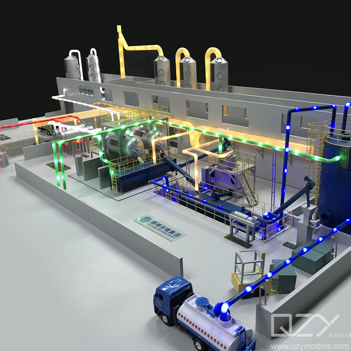
Can topographical models integrate lighting and interactive features?
Yes. Lighting, projection mapping, touch sensors, and removable elements enhance storytelling. Features include development phasing, traffic flows, and alternative design options. QZY Models designs serviceable systems that maintain interactivity while ensuring durability during exhibitions.
Has global demand for high-quality topographical models increased?
Yes. Rapid urbanization, mega-projects, and international competitions drive demand. Active markets include the Middle East, China, and Southeast Asia, with Europe and North America also utilizing models for heritage and infrastructure planning. QZY Models meets global demand through regional branches and centralized expertise, offering faster lead times and culturally attuned presentation styles.
Conclusion: How should you plan your next topographical model?
Start with clear objectives, scale, budget, and accurate survey or BIM data. Define interactive elements, key features, and milestones. Collaborating with QZY Models ensures precision, quality, and visually compelling results. Topographical models enhance urban planning, real estate, infrastructure, and educational projects by improving decision-making, communication, and stakeholder engagement.
FAQs
What is the difference between a topographical model and a site model?
A topographical model focuses on terrain and elevation, while a site model emphasizes buildings and layout with simplified or flat ground. Topographical models are essential where slopes and landforms influence design.
How long does it take to produce a topographical model?
Production ranges from weeks to months, depending on scale, complexity, interactivity, and approvals. Early data sharing and clear decisions shorten timelines.
What data is required to start a topographical model?
Survey points, DEMs, CAD or BIM files, site boundaries, and preliminary design information are needed. Supplementary references like aerial photos or planning diagrams help refine details.
Can topographical models be updated if designs change?
Yes. Many models feature removable buildings and landscape inserts, allowing updates without rebuilding the entire base.
Is international shipping of large models possible?
Yes. Modular construction, protective crates, lightweight materials, and clear assembly instructions ensure safe international delivery.
What is a topographical model?
A topographical model is a 3D representation of a landscape showing elevation, slopes, and physical features like hills, valleys, rivers, roads, and buildings. It provides a visual and scaled-down view of the terrain, helping planners, architects, and engineers understand the land’s relief and spatial relationships for design, construction, and environmental management.
Why are topographical models important in planning and design?
Topographical models allow architects, engineers, and urban planners to visualize how buildings, roads, and infrastructure fit the land. They help identify potential drainage issues, foundation challenges, and design conflicts, ensuring projects are feasible, safe, and well-integrated into the surrounding environment.
How do topographical models support engineering projects?
By accurately depicting elevation and land contours, topographical models help engineers design roads, pipelines, drainage systems, and other structures. They ensure efficient water flow, structural stability, and proper integration with natural terrain, reducing costly mistakes and improving construction precision.
What natural and man-made features do topographical models include?
Topographical models capture both natural elements, like mountains, valleys, rivers, and forests, and man-made structures, such as buildings, roads, utilities, and bridges. This combination provides a comprehensive spatial understanding of the area for planning, design, and environmental assessments.
How do topographical models aid environmental management?
These models help assess the impact of construction, land development, or conservation projects. They allow planners to manage resources, protect natural habitats, and evaluate changes to water flow or erosion patterns, supporting sustainable and informed decision-making.
In what ways do topographical models improve communication?
Topographical models make complex terrain easier to understand for stakeholders, including clients, construction teams, or community members. By providing a tangible, visual representation of the land, they improve collaboration, presentations, and decision-making for projects of all sizes.
What applications exist for topographical models outside construction?
Topographical models are used in landscaping, garden planning, urban design, hiking trail development, and educational purposes. They provide a realistic perspective of the terrain, helping users visualize and interact with the environment before making modifications or designs.
How does QZY Models utilize topographical models?
QZY Models specializes in creating precise topographical and architectural scale models. Their team uses these models to help clients visualize terrain, plan urban developments, and design complex projects with accuracy, ensuring both aesthetic and functional aspects are clearly communicated.