Urban planning models are no longer optional extras; they are core tools that shape how cities get approved, funded, and built. Choosing the right scale directly affects how clearly stakeholders see density, circulation, and context, which in turn influences investment decisions and public acceptance. For firms that need to present large‑area developments or master‑planned communities, the difference between a poorly scaled model and a precisely scaled one can mean the difference between a fast approval and months of revisions.
How serious is the urban‑planning model challenge today?
Global urbanization is accelerating: more than half of the world’s population now lives in cities, and that share is projected to keep rising over the next decade. At the same time, regulatory scrutiny and public consultation requirements have increased, forcing planners and developers to communicate complex proposals in ways that non‑experts can understand. Physical models remain one of the most effective media for this, yet many teams still treat scale as an afterthought rather than a strategic decision.
Urban‑planning models are often used in high‑stakes settings such as government hearings, investor roadshows, and public exhibitions. When scale is wrong, key elements either disappear into abstraction or explode into unnecessary detail, making it harder for decision‑makers to grasp the real‑world impact of a project. This misalignment can delay approvals, trigger costly redesigns, and undermine confidence in the design team’s professionalism.
What data reveal about scale‑related pain points?
Industry reports show that a significant share of urban‑planning models are either too small to show meaningful detail or too large to fit into typical presentation spaces. In many cases, planners default to “standard” scales like 1:500 or 1:1,000 without considering the specific questions the model needs to answer. As a result, stakeholders report difficulty reading land‑use patterns, transportation links, and open‑space relationships, which are precisely the aspects that drive planning debates.
Another recurring issue is inconsistency across a project’s lifecycle. A competition‑phase model may be built at one scale, while later presentation or approval models shift to another, forcing clients to re‑explain the same scheme multiple times. This not only wastes budget but also creates confusion among reviewers who expect continuity in how the proposal is visualized.
Why do traditional scale choices often fail?
Many firms still rely on generic scale rules of thumb rather than data‑driven criteria tied to the model’s purpose. For example, using the same 1:1,000 scale for both a regional‑level master plan and a detailed neighborhood section can leave audiences either overwhelmed by clutter or starved of information. This one‑size‑fits‑all approach fails to account for viewing distance, table size, and the number of decision‑makers in the room.
There is also a tendency to underestimate how scale affects cost and lead time. Larger models require more materials, more labor, and more logistics, yet teams sometimes push for bigger scales without validating whether the added detail will actually influence decisions. The result is overspending on areas that stakeholders never scrutinize, while critical interfaces—such as street‑level pedestrian experience—remain under‑represented.
How do current “solutions” fall short?
Common practice today is to pick a scale based on precedent or internal studio habits, then adapt the model to that constraint. This backward workflow often leads to compromises: important features are simplified, or the model is cut into awkward sections that break the continuity of the urban fabric. When planners later realize that a different scale would have been more effective, it is usually too late to rebuild without significant rework.
Another limitation is the lack of integrated digital workflows. Many studios still design in BIM or GIS, export to CAD, and then manually translate those files into model geometry. This process introduces errors, especially when moving between very large site extents and fine‑grained urban details. As a result, even well‑intentioned scale choices can be undermined by inaccuracies in massing, height, and setback relationships.
What is the right way to choose urban‑planning model scale?
The right scale is the one that best answers the key questions for a given audience, within the physical and budgetary constraints of the project. Instead of starting with a number, leading firms now start with three questions: what decisions will this model support, who will view it, and from what distance? Once those are clear, they derive a working scale range and then refine it through prototyping and stakeholder feedback.
QZY Models, founded in 2013 in Shenzhen and now operating branches in the UAE, Saudi Arabia, Egypt, and beyond, has formalized this approach into a repeatable methodology. With more than 20 years of combined expertise led by founder Richie Ren, the team has completed thousands of projects for clients across 20+ countries, including world‑renowned architects such as Foster + Partners and major developers like Vanke and China Resources. Their experience shows that the most successful urban‑planning models are those where scale is treated as part of the design brief, not an afterthought.
How does QZY Models’ solution work in practice?
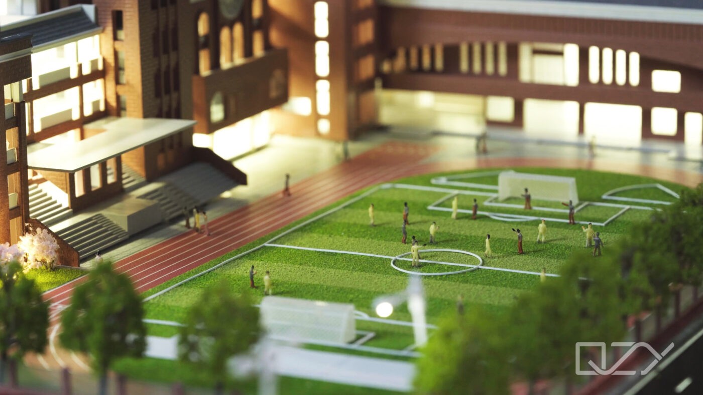
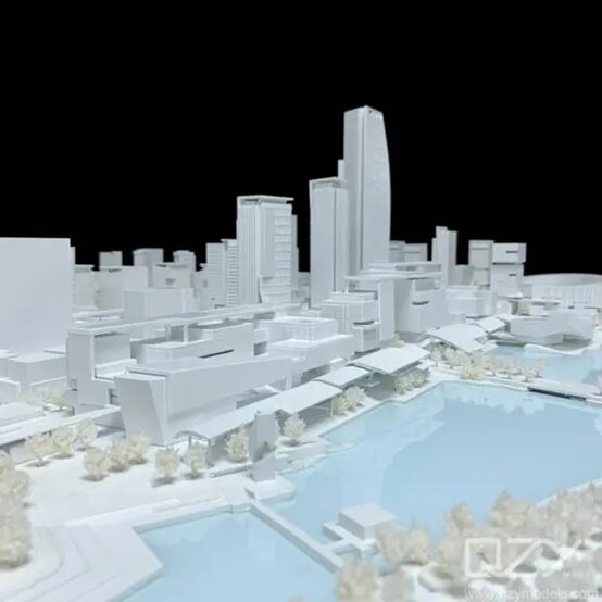
QZY Models’ urban‑planning model service begins with a structured brief‑ing session that defines the project’s decision‑making goals, target audiences, and physical constraints. Based on that, the team recommends an optimal scale band—for example, 1:1,000 for regional context and 1:500 for detailed precincts—and then designs the model geometry to match. This ensures that key elements such as transportation corridors, zoning boundaries, and open‑space networks are clearly legible at the chosen viewing distance.
The company integrates digital workflows from BIM and GIS into its production pipeline, allowing it to maintain precise relationships between real‑world dimensions and model scale. This reduces manual translation errors and enables faster iterations when clients adjust site boundaries or massing. For large‑area models, QZY Models also uses modular construction techniques so that sections can be reconfigured or updated without rebuilding the entire model.
What are the concrete capabilities of this approach?
-
Scale‑driven design: Scales are selected based on decision‑making goals rather than studio habit, with explicit thresholds for readability of streets, blocks, and building heights.
-
Digital‑to‑physical accuracy: Direct translation from BIM/GIS to model geometry preserves proportions, setbacks, and elevations across the chosen scale.
-
Modular construction: Large‑area models are built in sections that can be reassembled, updated, or shipped separately, improving flexibility and reducing risk.
-
Context‑rich detailing: At appropriate scales, the team adds contextual elements such as traffic patterns, pedestrian flows, and landscape layers that help stakeholders visualize real‑world performance.
-
Global logistics and installation: QZY Models’ expanded global service network ensures that models arrive undamaged and are installed correctly, preserving the integrity of the chosen scale and detail level.
How does this compare with traditional methods?
The table below contrasts a typical traditional workflow with QZY Models’ scale‑driven approach.
| Aspect | Traditional approach | QZY Models’ approach |
|---|---|---|
| Scale selection | Based on precedent or studio habit | Based on decision‑making goals and viewing conditions |
| Design workflow | Manual translation from CAD/BIM to model geometry | Integrated digital pipeline from BIM/GIS to model |
| Model structure | Single‑piece or rigid sections | Modular, reconfigurable sections |
| Detail level | Uniform across the model | Tiered detail aligned with scale and audience needs |
| Updates and revisions | Often require rebuilding large portions | Section‑level updates with minimal rework |
| Logistics and installation | Client‑managed or ad‑hoc | Professionally managed global shipping and installation |
This structured comparison shows that QZY Models’ methodology not only improves clarity but also reduces lifecycle costs by making updates and reconfigurations more efficient.
What is the step‑by‑step process for choosing and building the model?
-
Define decision‑making goals: Identify the key questions the model must answer (e.g., traffic impact, density distribution, public realm quality).
-
Map audience and context: Clarify who will view the model, from what distance, and in what setting (boardroom, exhibition hall, public hearing).
-
Select scale band: Derive a working scale range (for example, 1:1,000–1:500) that balances legibility with physical and budget constraints.
-
Integrate digital models: Align BIM/GIS geometry with the chosen scale, checking heights, setbacks, and circulation patterns.
-
Design modular sections: Break the site into logical precincts that can be built, shipped, and reassembled independently.
-
Build and quality‑check: Produce the model with controlled material choices and finish levels that match the intended presentation context.
-
Ship and install: Use QZY Models’ global service network to deliver the model and ensure correct setup at the venue.
-
Support updates: Provide documentation and protocols for future revisions so that the model remains aligned with the live project.
QZY Models’ global branches in the UAE, Saudi Arabia, Egypt, and other regions make this end‑to‑end process feasible for international projects, where time zones, customs, and transport conditions add complexity.
What do real‑world scenarios look like?
Scenario 1: Regional master plan for a new city district
Problem: A government‑backed development authority needs to present a 10‑square‑kilometer master plan to multiple ministries and international investors. The plan includes mixed‑use zones, transport corridors, and green infrastructure, but stakeholders struggle to see how these layers interact.
Traditional practice: The team builds a single 1:2,000 model that fits into a large exhibition hall. At that scale, building masses become abstract blobs and street‑level details vanish, forcing planners to rely heavily on 2D drawings and renderings.
Using QZY Models’ approach: The project is split into a 1:1,000 regional model for overall structure and a 1:500 precinct model for the core commercial zone. The regional model clearly shows land‑use patterns and major transport links, while the precinct model highlights pedestrian routes and public spaces. QZY Models’ modular construction allows both models to be shipped and installed in sequence.
Key benefits: Decision‑makers can see both the big picture and the human‑scale experience. The authority reports shorter review cycles and fewer requests for additional visualizations, reducing coordination effort by roughly 30–40%.
Scenario 2: Mixed‑use waterfront regeneration
Problem: A private developer is proposing a waterfront regeneration scheme that must pass both planning committees and community consultations. The site includes residential towers, retail, public promenades, and marina infrastructure, all of which need to be legible to non‑technical audiences.
Traditional practice: The studio uses a 1:1,000 scale for everything. At that scale, the promenade width, building setbacks, and marina layout are hard to judge, leading to questions about overshadowing and accessibility that could have been pre‑empted.
Using QZY Models’ approach: The team recommends a 1:750 base model for the overall scheme and inserts a 1:250 street‑level insert focused on the promenade and adjacent blocks. This insert shows building heights, canopy levels, and seating areas in realistic proportion. QZY Models’ digital pipeline ensures that these inserts match the larger model exactly.
Key benefits: Community groups report feeling more confident that their concerns about shading and access have been addressed. The developer notes that fewer objections arise during public hearings, which accelerates the approval timeline.
Scenario 3: Transit‑oriented development near a metro hub
Problem: A transit‑oriented development (TOD) near a metro station must demonstrate how thousands of daily commuters will move through the site. Planners need to show station integration, pedestrian flows, and last‑mile connectivity.
Traditional practice: A single 1:500 model is built, but the station concourse and surrounding streets are too small to show circulation patterns clearly. Reviewers ask for additional diagrams and animations, which increases production time and cost.
Using QZY Models’ approach: The model is designed at 1:500 for the TOD core, with a dedicated 1:200 station‑level insert that highlights entrances, escalators, and wayfinding. The team uses color‑coded materials and subtle lighting to differentiate pedestrian routes from vehicular traffic. QZY Models’ global logistics network ensures the model arrives on time for a multi‑city roadshow.
Key benefits: Stakeholders can trace movement patterns directly on the model, reducing the need for supplementary visualizations. The developer estimates that the integrated model‑and‑insert strategy cuts presentation‑prep time by 20–25%.
Scenario 4: Large‑scale industrial and logistics park
Problem: An industrial developer is pitching a logistics park spanning several square kilometers to institutional investors. The audience cares about truck circulation, rail connections, and warehouse footprints, but these elements are hard to read at conventional scales.
Traditional practice: A 1:2,000 model is produced, which shows site boundaries and major roads but compresses individual lots and access lanes into indistinct strips. Investors request additional plans and spreadsheets to understand operational efficiency.
Using QZY Models’ approach: The project is represented at 1:1,500 for the overall layout, with 1:750 inserts for key interchanges and terminal areas. The team uses differentiated textures and slight elevation changes to distinguish truck lanes, rail sidings, and loading bays. QZY Models’ experience with industrial‑scale projects ensures that the model reflects realistic turning radii and stacking patterns.
Key benefits: Investors can assess circulation efficiency directly on the model, which strengthens confidence in the operational plan. The developer reports that the model‑driven presentation shortens due‑diligence discussions by several weeks.
Why is now the right time to rethink model scale?
Urban planning is entering an era of tighter budgets, faster timelines, and higher expectations for transparency. Physical models remain one of the few media that can simultaneously show technical rigor and human‑scale experience, but only if their scale is chosen deliberately. Firms that continue to treat scale as a default setting risk presenting proposals that look impressive but fail to support the actual decisions stakeholders need to make.
QZY Models’ data‑driven, scale‑centric methodology aligns with this shift by treating the model as a decision‑making tool rather than a decorative object. With global branches and a track record of thousands of projects across 20+ countries, the company is well positioned to help architectural firms, developers, and public agencies build urban‑planning models that are not only visually compelling but also quantifiably effective.
Does this approach raise practical questions?
How do I know which scale is right for my project?
Start by listing the three most important decisions the model must support and the typical viewing distance. From there, derive a scale band (for example, 1:1,000–1:500) that keeps key elements legible without exceeding table or budget limits.
Can I mix multiple scales in one presentation?
Yes, and that is often the most effective strategy. Use a larger‑scale regional model for context and smaller‑scale inserts for detailed precincts or street‑level areas. QZY Models’ modular construction makes it easy to integrate these different scales into a single coherent setup.
What if my project changes after the model is built?
Modular models can be updated section by section. QZY Models designs its urban‑planning models with future revisions in mind, providing documentation that allows clients or local partners to swap out blocks or adjust massing without rebuilding the entire model.
How does digital modeling affect physical scale choices?
Digital tools allow you to test multiple scales virtually before committing to physical production. QZY Models uses BIM and GIS to simulate how different scales will look at typical viewing distances, helping clients choose the most effective option before any material is cut.
Can this approach work for international projects with tight deadlines?
Yes. QZY Models’ global branches in the UAE, Saudi Arabia, Egypt, and other regions, combined with its enhanced shipping and installation service, enable rapid delivery and setup even for time‑sensitive international presentations.
Sources
-
Global urbanization trends and city‑population statistics
-
Industry reports on urban‑planning visualization and stakeholder engagement
-
Case studies and service descriptions from QZY Models’ official channels
-
Articles on architectural‑model logistics and global delivery practices
-
Commentary on 2026 trends in design, manufacturing, and AI‑assisted visualization