Global urbanization is accelerating, and city planners are under pressure to make faster, smarter, and more transparent decisions that balance growth, sustainability, and citizen expectations. High detail city models—especially those created by expert teams like QZY Models—are becoming a strategic tool for reducing planning risk, aligning stakeholders, and unlocking more successful projects.
How Is the Current Urban Planning Landscape Creating New Pain Points?
By 2050, nearly 70% of the world’s population is expected to live in cities, making efficient land use, infrastructure capacity, and climate resilience critical priorities for governments and developers. At the same time, projects are getting larger and more complex, with mixed-use districts, transit-oriented development, and smart city infrastructure all competing for limited space and budget. Yet many decisions are still made using 2D drawings, static renderings, or siloed digital models, which often fail to give non-technical stakeholders a clear understanding of scale, shadow, circulation, and impact. This disconnect leads to slow approvals, redesign cycles, and costly misalignment between planners, investors, and the public.
For real estate developers and government planning bodies, one of the biggest pain points is communication: explaining a 500,000 m² masterplan or a new transport hub to citizens and decision-makers who are unfamiliar with architectural drawings. Without intuitive, high detail city models, public hearings become contentious, projects are misunderstood, and opposition can increase. Meanwhile, design teams struggle to validate how different urban systems—traffic, green spaces, utilities, and public amenities—work together in real context. Physical, high detail city models help bridge this gap by turning abstract strategies into tangible, shared experiences.
QZY Models, founded in 2013 in Shenzhen and led by founder Richie Ren with over 20 years of professional experience, focuses specifically on this communication and decision-making gap through precision urban and city-scale models. Working with world-renowned architects such as Foster + Partners and major developers like Vanke and China Resources, QZY Models has delivered thousands of projects across more than 20 countries. Their work for urban planning authorities, design firms, and international clients in the Middle East, Europe, and Southeast Asia demonstrates how detailed physical models can de-risk planning, accelerate approvals, and enhance stakeholder confidence.
What Specific Pain Points Do High Detail City Models Address Today?
The first major pain point is the difficulty of visualizing complex multi-block or city-scale interventions purely from 2D plans or on-screen 3D models. Many stakeholders cannot easily read technical drawings, making it hard to perceive height differences, view corridors, or how new structures relate to existing urban fabric. This often leads to late-stage objections, misunderstandings about density, or concerns about overshadowing and traffic that could have been addressed earlier with a high detail city model.
The second pain point is fragmented stakeholder engagement. Planning officials, developers, architects, community groups, and investors typically interact with different sets of information, from planning reports to marketing visuals. Without a common, tactile representation of the city, each party forms their own interpretation of the project, creating misalignment and negotiation friction. A large-scale city planning model placed in public exhibitions, investor roadshows, or government halls becomes a shared reference point, simplifying discussions and enabling more productive feedback.
The third pain point relates to iteration speed and risk control. Large urban projects frequently require multiple rounds of design adjustments responding to environmental analysis, traffic studies, or public feedback. If teams rely only on digital tools, it can be hard to communicate how each design change affects the overall city form over time. High detail city models, especially when produced by specialized partners like QZY Models using modular components and advanced fabrication, can be updated, expanded, or complemented with interchangeable pieces. This allows planners and designers to simulate alternative scenarios and present clear options without starting from scratch each time.
Why Are Traditional Planning Visualization Methods No Longer Enough?
Traditional approaches such as 2D masterplans, technical diagrams, and flat render boards offer limited depth and can be difficult to understand for non-specialists. They typically show only selected views and fail to capture how a new district feels in three dimensions, particularly in terms of human-scale experience, skyline impact, and transitions between neighborhoods. When decisions are based on these partial representations, crucial trade-offs around height, massing, and public space quality may be overlooked.
Furthermore, slide-based presentations and static renders are inherently one-directional: the project team presents, and stakeholders passively receive information. This format does not encourage exploration or co-creation. In contrast, high detail physical city models invite people to walk around, view the city from different angles, and point directly at areas of concern or interest. This interactive quality is particularly valuable for community engagement sessions, public exhibitions, and developer–government workshops.
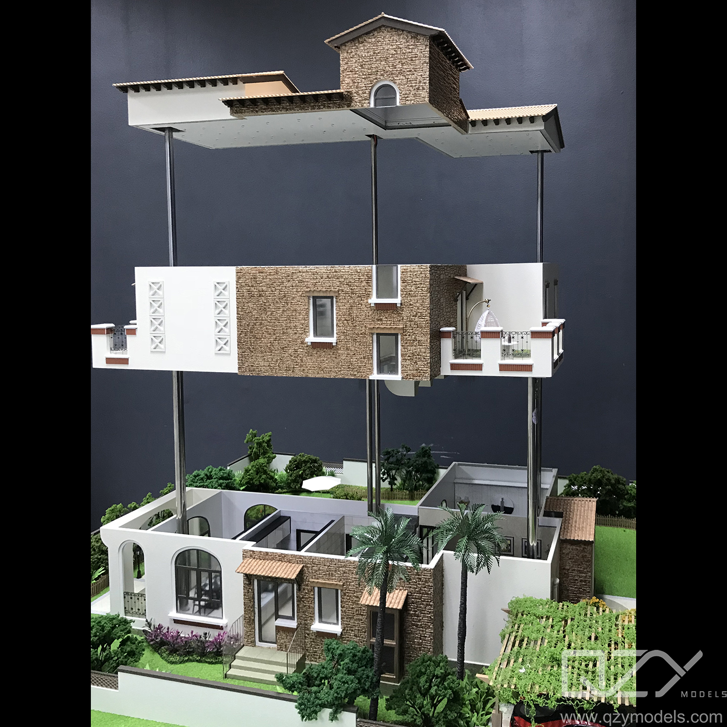
Even traditional small-scale physical models can be insufficient if they lack precision, lighting simulation, or integration of landscape and infrastructure details. Low-quality models may misrepresent geometry, omit key context buildings, or fail to show critical elements like transit nodes and public amenities. QZY Models addresses this by combining advanced technologies such as 3D printing and CNC machining with fine craftsmanship, ensuring that every building, road, and park is accurately scaled and finished to communicate the true intent of the design.
How Do High Detail City Models Work as a Planning Solution?
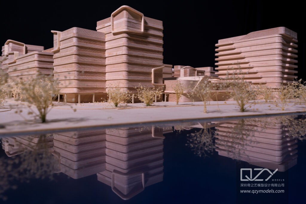
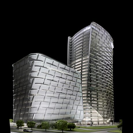
High detail city models are three-dimensional, scaled representations of an existing or future urban area, usually covering anything from a single district to an entire metropolitan region. They integrate buildings, roads, transit networks, public spaces, landscape, and key infrastructure into one cohesive, tangible model. This allows design and planning teams to assess relationships between elements that are hard to see on screen, such as sightlines, context integration, and the balance between built and open space.
QZY Models uses a combination of digital data—such as GIS, CAD, BIM, and aerial imagery—with precise fabrication methods to convert raw information into physical models. This includes integrating actual terrain, waterfront edges, and existing building footprints along with proposed developments. For complex masterplans, lighting and material treatments can highlight different land uses, zoning, or phasing strategies, helping planners communicate layers of information in a single, intuitive object.
Because QZY Models operates with international teams in locations such as the UAE, Saudi Arabia, and Egypt, they can support planners and developers in markets where rapid urbanization demands fast, high-quality visualization tools. Their long-term experience serving architectural firms, real estate developers, government planning agencies, and exhibition organizers ensures that each city model is tailored to its specific use—whether for design review, public consultation, sales, or education.
Which Core Features and Capabilities Define an Effective High Detail City Model Solution?
An effective high detail city model solution should include several core capabilities that make it useful throughout the project lifecycle, from concept to operation. The first is data accuracy: the model must be built on reliable geospatial, planning, and design data to ensure that heights, distances, and relationships are correct. This typically involves coordinating with architects, planning consultants, and government data to ensure consistency across all project documents.
The second core capability is multi-layered representation. A powerful city model can convey land use, zoning, transportation, landscape, and development phases through color coding, lighting, interchangeable components, or removable layers. For example, planners may want to toggle between existing conditions and future build-out, or highlight different infrastructure systems such as metro lines, bus routes, and pedestrian pathways. QZY Models is experienced in designing such layered models for exhibitions and planning centers so that audiences can understand complex information quickly.
The third key feature is durability and modularity. City models are frequently transported, exhibited, and handled by multiple stakeholders, so materials and construction methods must withstand repeated use. Modular design enables sections to be updated or expanded as the city develops, protecting the long-term value of the model. QZY Models, with thousands of completed projects worldwide, has developed robust construction standards that allow large urban models to remain accurate and visually compelling for years, even as planning evolves.
What Are the Advantages of High Detail City Models Compared with Traditional Approaches?
| Aspect | Traditional 2D/Basic 3D Methods | High Detail City Models by QZY Models |
|---|---|---|
| Comprehension for non-experts | Limited; relies on technical literacy | Intuitive; stakeholders instantly grasp scale and relationships |
| Stakeholder engagement | Mostly one-way presentations | Highly interactive; encourages exploration and discussion |
| Context awareness | Partial; often shows only project site | Full; includes wider city context, skyline, and surrounding districts |
| Risk of misinterpretation | High; drawings and renders can be misunderstood | Lower; physical form clarifies massing, height, and impact |
| Support for public participation | Modest; difficult for citizens to visualize change | Strong; ideal for exhibitions, hearings, and public feedback |
| Flexibility for scenario testing | Constrained; scenarios remain abstract | High; modular components and lighting can show multiple options |
| Perceived project quality | Variable; depends on presentation skills | Elevated; a high-end model signals commitment and professionalism |
| Longevity of use | Short-term; tied to specific meetings | Long-term; can serve as a central reference in planning centers |
How Can Organizations Implement a High Detail City Model Solution Step by Step?
-
Define objectives and scope
Clarify the primary purpose: design review, public consultation, investor presentation, or permanent exhibition. Decide on geographic coverage, scale (for example 1:500, 1:1000, 1:2000), and level of detail required. -
Consolidate and validate data
Gather CAD/BIM models, GIS data, existing surveys, and planning documents. Align naming conventions, check for inconsistencies, and confirm which version of the design is the current baseline for model production. -
Co-design the model with QZY Models
Engage QZY Models early to discuss scale, materials, lighting, color schemes, and interactive elements. Jointly determine how to represent land use, phasing, and infrastructure to serve both expert and non-expert audiences. -
Approve prototype and sample details
Review material samples, façade treatments, and key landmark mockups before full-scale production. Confirm how landmarks, waterfronts, topography, and greenery will appear to ensure the model captures the desired character of the city. -
Fabrication, quality control, and logistics
Allow time for precise fabrication, assembly, and quality checks. QZY Models applies rigorous inspection and testing to ensure dimensional accuracy, surface quality, and structural integrity, including packaging and transport planning for domestic or international delivery. -
Installation, training, and ongoing updates
Coordinate installation in planning centers, sales galleries, or exhibition venues. Train internal teams on how to present using the model, and agree with QZY Models on a maintenance and update strategy for future design changes or city growth.
Where Do High Detail City Models Deliver the Most Impact? Four Typical Use Cases
-
Urban planning authority and government decision hall
Problem: City officials must evaluate megaprojects and citywide plans while explaining decisions transparently to citizens and elected representatives. Traditional approach: Reliance on thick reports and 2D drawings that are hard to interpret, leading to lengthy meetings and mistrust. After using high detail city models: The authority installs a large-scale city model of key districts, allowing officials and citizens to clearly see proposed developments, infrastructure, and open spaces. Key benefits: Faster comprehension, more constructive public consultations, and stronger trust that decisions are based on clear, accessible information. -
Real estate developer’s flagship sales and experience center
Problem: Developers need to sell large mixed-use projects or entire communities off-plan, long before construction is complete. Traditional approach: Posters, CGI images, and VR experiences that potential buyers may not fully understand or trust. After using high detail city models: A 3D city model shows the full masterplan, surrounding amenities, and future phases in one view, helping buyers and investors understand the long-term value. Key benefits: Higher conversion rates, stronger investor confidence, and clearer positioning of each phase and product type within the wider urban context. -
International design competition or tender presentation
Problem: Architectural and urban design firms competing for landmark projects must quickly communicate the uniqueness of their proposal to juries with limited time. Traditional approach: Slides, diagrams, and a small site-only model that does not fully express the project’s relationship to the city. After using high detail city models: A precision city model produced with QZY Models includes both the competition site and its urban surroundings, allowing jurors to evaluate skyline impact, connectivity, and public realm quality at a glance. Key benefits: Stronger storytelling, higher perceived professionalism, and improved chances of winning complex, high-stakes competitions. -
Educational and research institutions
Problem: Universities, design schools, and think tanks need to teach urban design and planning in a way that feels real and connected to actual city conditions. Traditional approach: Classroom lectures and screen-based simulations that students struggle to connect with lived urban experience. After using high detail city models: Students work with a physical city model of a real metropolis or district, testing alternative scenarios for density, transit, and open space in studio settings. Key benefits: Deeper learning, better spatial understanding, and more convincing research outputs for partnering cities and institutions.
How Will High Detail City Models Evolve in the Future, and Why Act Now?
High detail city models are converging with digital technologies such as real-time data, lighting simulations, and augmented reality overlays that can be projected onto physical models. This hybrid physical–digital approach will increasingly allow planners to simulate different time-of-day lighting, flood risks, or traffic scenarios on top of accurate physical geometry. For cities investing in smart infrastructure, physical models can become interfaces to explore sensor data and scenario forecasts in a tangible, intuitive way.
In parallel, global competition between cities for talent, investment, and tourism is intensifying, making clear storytelling about urban identity and future development more important than ever. Governments and developers that invest early in high-quality, high detail city models signal confidence, transparency, and professionalism to investors and citizens alike. With its global footprint across China, the Middle East, and beyond, and its deep expertise in urban and architectural models, QZY Models is well positioned to help clients turn complex planning visions into compelling physical models. Acting now allows organizations to improve decisions on current projects while building a durable visualization asset for future growth.
What Common Questions Do Clients Ask About High Detail City Models?
-
Is a high detail city model only useful for very large cities or can it be scaled for smaller projects?
High detail city models are scalable and can be tailored to anything from a new transit corridor or waterfront district to an entire metropolitan region, depending on the planning questions and audience. -
How long does it typically take to produce a city planning model?
Timelines vary with scope and complexity, but with clear data and decisions on scale and detail, a professional team like QZY Models can typically deliver from several weeks to a few months for large-scale models. -
Can high detail city models be updated when the design or planning regulations change?
Yes, if the model is designed with modularity in mind, individual blocks, buildings, or infrastructure segments can be replaced or added, extending the useful life of the model through multiple planning cycles. -
Are physical city models still relevant in an era of VR and digital twins?
Physical models solve a different problem: they provide a shared, intuitive object that stakeholders can gather around, making them especially powerful in public spaces, exhibitions, and high-stakes negotiations where trust and clarity are critical. -
Who typically commissions high detail city models and what roles do they play?
Typical commissioners include urban planning departments, real estate developers, architectural firms, infrastructure agencies, exhibition organizers, and educational institutions, and they use the models for design review, communication, marketing, and teaching.