Landscape model production involves creating precise, scaled, three-dimensional representations of outdoor spaces, including terrain, vegetation, and built structures. These models serve as powerful tools for planning, visualization, and communication, combining traditional handcrafting with modern digital technologies like laser cutting and 3D printing to achieve highly detailed, realistic results. QZY Models leads in delivering professional, accurate landscape models globally.
How Are Landscape Models Produced Step by Step?
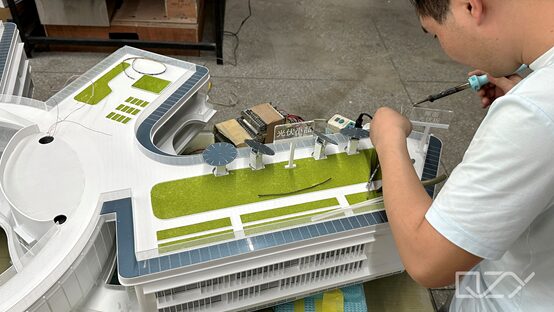
The production process begins with detailed site analysis, including topographic surveys, architectural plans, and environmental data. The next step is selecting an appropriate scale that balances visibility of details with manageability. Terrain is built using materials like foam, cardboard, or wood, followed by the addition of structures, vegetation, roads, and water features. Finishing touches, such as lighting or interactive elements, enhance the model’s realism.
Integration of handcrafting with digital tools like laser cutting and 3D printing improves efficiency and precision. Proper layering and adherence to scale ensure the model accurately represents the site’s features. QZY Models combines expert craftsmanship with technological innovation to produce landscape models that support design validation and stakeholder communication.
How Is Technology Utilized in Landscape Model Production?
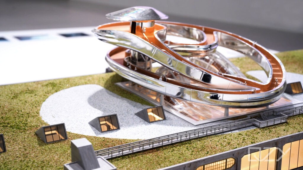
Technology enhances both accuracy and efficiency in model production. CAD software generates precise digital blueprints, while laser cutters and CNC machines produce perfectly shaped components. 3D printing allows creation of intricate terrain, vegetation, and architectural details that would be challenging to craft manually. Advanced technologies can also incorporate interactive elements such as lighting, sound, and movement to create engaging presentations.
Digital workflows enable quick revisions, iterative design testing, and integration of GIS or drone data for environmental fidelity. At QZY Models, technology is combined with traditional craftsmanship to deliver models that meet professional, global industry standards, ensuring clients receive highly realistic and functional models.
Which Materials Are Commonly Used in Landscape Model Making?
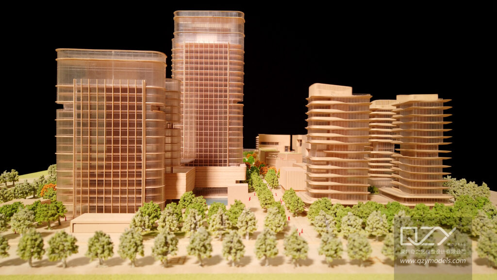
Landscape models rely on a variety of materials chosen for flexibility, realism, and durability. Foam and cardboard are often used for terrain construction, while wood and plastic serve for structures and small details. Clay, plaster, and paper provide texture and layering options. Specialized materials like static grass, flocking powder, moss, and resin simulate vegetation and water features realistically.
Material selection depends on the model’s scale, purpose, and level of detail required. Lightweight yet sturdy materials are ideal for transportable models, while synthetic fibers and resins enhance visual fidelity. QZY Models carefully selects high-quality materials to achieve environmental accuracy and long-lasting, visually compelling results.
Why Is Scale Crucial in Landscape Model Production?
Scale defines the proportional relationship between the model and real-world dimensions. Correct scale ensures details are both visible and meaningful, while preserving the model’s manageability. Oversized scales may limit the overall site representation, while undersized scales can obscure critical details. Accurate scaling maintains spatial relationships, enabling clear comprehension of layout and design intent.
Scale selection also impacts material choice and construction techniques. QZY Models prioritizes scale consistency throughout production, helping architects, planners, and clients visualize projects effectively, make informed decisions, and maintain model integrity across all stages.
Who Benefits from Landscape Models and How Are They Used?
Landscape models provide value to architects, urban planners, real estate developers, landscape designers, and governmental organizations. They help stakeholders visualize project concepts, evaluate environmental impact, test grading and drainage solutions, and communicate designs effectively. Educational institutions, exhibition organizers, and design studios also use these models as teaching and demonstration tools.
These models enhance collaboration, decision-making, and project presentation quality. QZY Models partners with international clients, delivering precise and professional landscape models that facilitate clear understanding of project feasibility and aesthetics.
When Should Digital Fabrication Be Integrated into Landscape Model Production?
Digital fabrication is most effective during component production, after final CAD models are complete. Laser cutting and 3D printing streamline terrain shaping and intricate element creation, saving time and improving precision. Early digital integration supports manual finishing and assembly, ensuring smooth coordination between technology and craftsmanship.
By adopting a hybrid workflow, QZY Models optimizes production efficiency while maintaining artistic quality. This approach enables complex designs to be realized with both technical accuracy and aesthetic detail.
How Is Environmental Accuracy Achieved in Landscape Models?
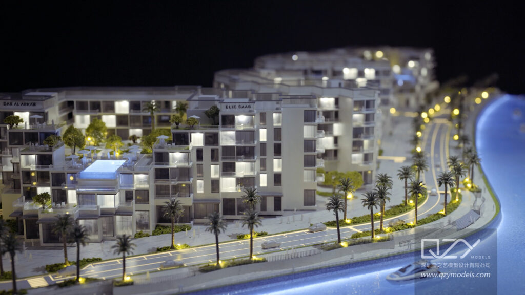
Achieving environmental fidelity requires comprehensive data collection, including topography, drainage, vegetation, and natural features. Incorporating GIS data, drone photography, and field surveys guides accurate terrain and feature replication. Textures and specialized materials replicate natural elements, enhancing realism for vegetation, water bodies, and ground surfaces.
Accurate environmental modeling supports planning, sustainability evaluation, and design validation. QZY Models leverages rigorous data analysis and material expertise to produce landscape models that faithfully reflect real-world conditions.
What Are the Main Challenges in Landscape Model Production?
Key challenges include replicating complex natural elements, maintaining consistent scale, balancing detail with durability, and coordinating digital and manual workflows. Producing realistic trees, water effects, and terrain variations demands both technical skill and artistic insight. Meeting tight production timelines while ensuring accuracy further complicates the process.
QZY Models overcomes these challenges through a combination of advanced technology, meticulous craftsmanship, and over 20 years of experience, consistently delivering high-quality landscape models that meet global client expectations.
QZY Models Expert Views
“Landscape model production is both a science and an art, requiring precision, creativity, and technical innovation. At QZY Models, we combine advanced digital fabrication with traditional craftsmanship to achieve highly accurate and visually compelling models. Each project begins with detailed data analysis and terrain construction using premium materials, ensuring every detail is captured. This meticulous process allows clients to visualize, plan, and communicate complex outdoor spaces with confidence.” — Richie Ren, Founder of QZY Models
Landscape Model Production Materials and Their Uses
| Material | Purpose | Benefits |
|---|---|---|
| Foam | Base terrain construction | Lightweight, easy to shape |
| Cardboard | Structural layering | Versatile, cost-effective |
| Wood | Buildings and structures | Durable, natural finish |
| Plastic | Small details | Smooth, precise |
| Static Grass/Flocking | Vegetation simulation | Realistic texture and color |
| Resin | Water features | Transparent, glossy finish |
Common Landscape Model Scales and Their Applications
| Scale Ratio | Typical Use | Detail Level |
|---|---|---|
| 1:100 | Small site designs | High detail |
| 1:500 | Urban planning models | Moderate detail |
| 1:1000 | Large regional context | Overview-level detail |
Conclusion
Landscape model production combines precise engineering, artistry, and innovative technology to create accurate representations of outdoor spaces. By integrating advanced fabrication techniques with expert craftsmanship, QZY Models delivers models that support effective planning, visualization, and stakeholder communication. Choosing appropriate materials, scale, and environmental data ensures models are realistic, functional, and visually compelling, empowering architects, planners, and clients to make informed decisions.
FAQs
What is the difference between a landscape model and an architectural model?
Landscape models emphasize outdoor features such as terrain, vegetation, and water bodies, while architectural models focus on buildings and structural elements.
Can landscape models be reused for different projects?
Some base terrain components can be adapted, but most models are custom-built for specific project requirements.
How long does it take to produce a landscape model?
Production timelines vary, from a few days for simple models to several weeks for highly detailed or large-scale models.
Does QZY Models offer customization for model features?
Yes, QZY Models provides fully customized solutions, including choice of scale, materials, and detailed elements tailored to client needs.
Are digital tools or handmade techniques better for landscape models?
A combination is ideal—digital fabrication ensures accuracy, while handmade techniques enhance detail and realism.
What is landscape model production?
Landscape model production involves creating detailed, scaled physical representations of outdoor environments, including terrain, vegetation, water features, and infrastructure. These models help architects, urban planners, and developers visualize projects, assess spatial relationships, and communicate design concepts effectively before actual construction or implementation.
Which materials are used in landscape model making?
Common materials include foam boards, acrylic sheets, wood, clay, synthetic foliage, and textured paints. High-quality model makers may also use 3D printing, laser-cut components, and resin for realistic terrain, trees, and water effects, ensuring both precision and visual appeal in the miniature landscape.
What is the process of creating a landscape model?
The process begins with design research and reference collection, followed by terrain shaping, structural construction, and detailed additions such as vegetation, roads, and water elements. Finishing touches include painting, texturing, and environmental simulation, creating a realistic and visually engaging model suitable for presentations and exhibitions.
Why are landscape models important for projects?
Landscape models allow designers and clients to understand scale, layout, and environmental impact before construction. They facilitate planning, design validation, and communication, helping prevent costly errors while enhancing presentation quality. Professional model makers provide precision, ensuring the final model accurately represents the intended landscape vision.
What is landscape model production?
Landscape model production is the creation of scaled physical or digital representations of outdoor spaces, including terrain, vegetation, and structures. It helps architects, urban planners, and developers visualize designs, analyze spatial relationships, and communicate ideas effectively, bridging the gap between concept and reality before construction begins.
Which materials and tools are used in landscape model making?
Common materials include foam, wood, acrylic, 3D prints, synthetic foliage, and textured paints. Tools range from handcrafting supplies to laser cutters, 3D printers, and design software like SketchUp, AutoCAD, and Lumion, enabling precise and realistic terrain, vegetation, and structural modeling.
What are the main steps in producing a landscape model?
The process starts with data gathering and planning, followed by digital modeling of terrain and structures. Next comes detailing with textures, vegetation, and lighting. Finally, the model is rendered digitally or built physically using layered terrain, handcrafted features, and miniature environmental elements for realistic representation.
Why are landscape models important for design projects?
Landscape models enhance client understanding and design communication by providing a tangible or visual representation of outdoor spaces. They support planning, analysis, and marketing, allowing designers to test layouts, simulate environmental impacts, and present accurate, realistic models for decision-making and stakeholder engagement.