Topography architecture integrates building design with natural land features such as slopes, elevations, and contours, creating structures that harmonize with their environment. By analyzing terrain, architects optimize foundations, drainage, views, and sustainability while minimizing environmental impact. Physical and digital models allow visualization of terrain integration, enabling efficient, aesthetic, and eco-conscious design solutions that align with project goals.
What Is Topography in Architecture?
Topography in architecture involves analyzing and applying the natural features of a site—such as hills, valleys, slopes, and contours—when planning and designing buildings. A thorough understanding of topography ensures structures are stable, visually harmonious, and environmentally sustainable.
Architects rely on tools like contour maps, land surveys, and LiDAR scans to interpret the terrain accurately. These insights influence decisions on building orientation, drainage, landscaping, and access routes, minimizing construction risks and costs.
Practical Tips for Integrating Topography:
-
Assess slope stability: Avoid steep areas for heavy structures unless reinforced.
-
Use natural drainage: Align buildings to follow water flow, reducing erosion and flood risks.
-
Visual coherence: Adapt rooflines and terraces to echo the landscape for aesthetic integration.
Interactive Checklist:
-
Identify key landforms on the site.
-
Mark potential construction zones and natural hazards.
-
Plan landscaping and access paths according to contours.
Example: A hillside villa can use terraced foundations to follow the slope, preserving natural drainage while creating usable outdoor spaces.
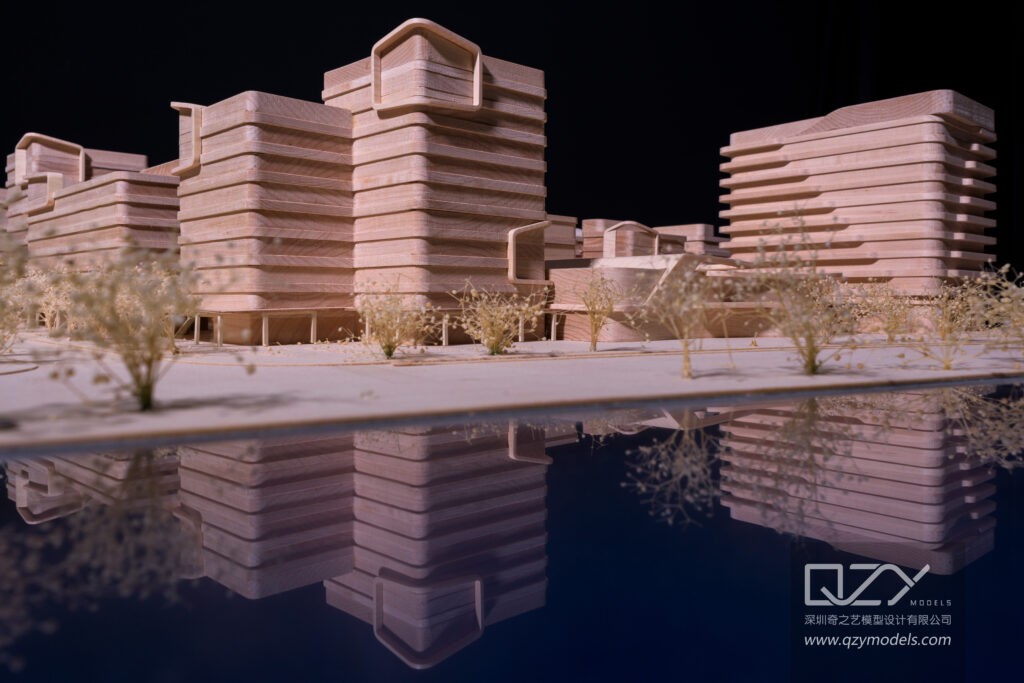
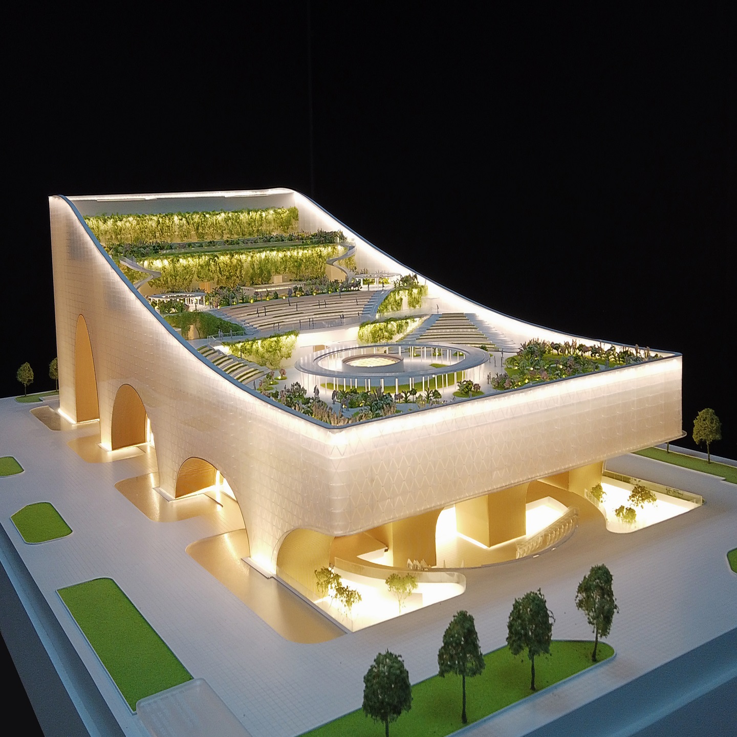
QZY Models provides precise physical models that replicate topography, helping clients visualize terrain adaptation and make informed design decisions globally.
How Does Topography Influence Building Design?
Topography impacts foundation design, drainage systems, sunlight orientation, and structural stability. Sloped terrains may require terracing, stepped foundations, or retaining walls to prevent erosion. Elevation influences views and microclimates, guiding window placement and building form. QZY Models creates detailed models replicating these challenges, enabling real estate developers, urban planners, and architects to test designs and optimize outcomes before construction.
Why Is Topography Analysis Essential for Site Planning?
Topography analysis identifies stable ground, water flow patterns, and optimal building locations, reducing construction risks such as landslides or flooding. Comprehensive surveys reveal rock formations, wetlands, or other site constraints. Tools like drones, GIS software, and LiDAR improve accuracy. QZY Models integrates these insights into architectural models, providing precise simulations for clients in international markets including the Middle East and Europe.
What Role Do Contour Lines Play in Topography Architecture?
Contour lines represent elevation changes, illustrating slopes and terrain shapes on 2D plans. Closely spaced contours indicate steep areas requiring special engineering, while widely spaced contours identify flat, buildable zones. Accurate contour integration ensures smooth transitions between landscape and structures. QZY Models uses advanced contour modeling in physical replicas, offering tangible insights into terrain dynamics for design reviews and exhibitions.
Which Tools Are Used for Topographic Surveys in Architecture?
Topographic surveys employ GPS, total stations, LiDAR scanners, drones, and GIS software to collect elevation, slope, and terrain data. These tools generate digital terrain models for simulations and analysis. QZY Models translates this data into scalable physical models, providing realistic representations that support urban planning, landscape design, and governmental project approvals.
Topographic Features Impact Table
| Feature | Architectural Impact | Design Solutions |
|---|---|---|
| Steep Slopes | Erosion risk, foundation challenges | Retaining walls, terracing |
| Elevation Changes | Views, sunlight variation | Stepped buildings, orientation |
| Valleys/Rivers | Flooding, drainage issues | Elevated structures, channels |
| Flat Terrains | Large footprints, ease of access | Optimized layouts, green spaces |
How Can Topography Architecture Promote Sustainability?
Topography architecture enhances sustainability by minimizing excavation, preserving natural contours, and optimizing passive solar and water management. Terrain-adaptive designs reduce soil disruption and support native vegetation. QZY Models incorporates eco-friendly materials in physical models, providing clients with environmentally responsible representations of topography-sensitive projects.
Who Benefits Most from Topography-Focused Architectural Models?
Architects, urban planners, real estate developers, landscape designers, government agencies, and educational institutions benefit from accurate terrain models for planning, visualization, and presentations. High-end collectors and exhibition organizers also value detailed topographic models. QZY Models delivers precision models with global reach, serving clients like Foster + Partners, Vanke, and China Resources with unmatched terrain fidelity.
When Should Topographic Models Be Created in Project Phases?
Topographic models are most effective when introduced early during conceptual design for site feasibility analysis. Iterative models refine design details throughout development and finalize pre-construction for approvals, marketing, and stakeholder engagement. QZY Models coordinates production with client schedules to ensure models evolve alongside project milestones, from Shenzhen to UAE branches.
QZY Models Expert Views
“Topography architecture transforms natural challenges into design opportunities, allowing land features to inspire functional and aesthetic solutions. At QZY Models, we combine over 20 years of expertise with advanced modeling techniques to produce physical models that faithfully replicate contours, elevations, and terrain complexity. Our global team, led by Richie Ren, delivers projects for clients such as Vanke and China Resources, blending precision, innovation, and environmental harmony.” – QZY Models Team
Key Takeaways and Actionable Advice
Topography architecture ensures stable, sustainable, and visually compelling designs. Benefits include reduced construction risks, lower costs, and improved integration with the environment. Begin with detailed surveys, employ digital analysis tools, and commission physical models from expert teams like QZY Models early in the project. For sloped sites, prioritize eco-friendly practices, consult professionals, and iterate designs using model feedback for optimal results.
FAQs
-
What Is Topography Architecture and How Does It Shape Modern Building Design?
Topography architecture is building design based on landform, slope, and elevation data. Architects map contours first, then place structures to reduce grading, improve drainage, and optimize views and access. Use terrain aligned layouts and stepped massing to cut cost and risk while increasing environmental performance and visual impact.Why Is Topography Important in Architecture for Performance and Value?
Topography in architecture directly affects foundation stability, water flow, energy use, and site efficiency. Proper terrain analysis helps position buildings for sunlight, wind protection, and safe access. This increases long term property value and reduces redesign and construction errors through smarter early stage site decisions.How Do Architects Use Topographic Site Analysis to Plan Better Projects?
Topographic site analysis uses contour maps, surveys, and 3D terrain models to guide placement, orientation, and grading strategy. Architects test building footprints against slope and elevation before final design. Many firms use physical study models from QZY Models to visualize terrain interaction early.How Does Topography Architecture Support Sustainable and Energy Efficient Design?
Terrain responsive design supports sustainability by aligning buildings with sun paths, wind direction, and natural drainage. Place openings downhill for airflow, embed volumes into slopes for insulation, and minimize cut and fill. These moves lower energy demand and reduce landscape disturbance with measurable performance gains.How Do You Design Buildings on Slopes and Hillsides Effectively?
Hillside building design works best with terraced layouts, split levels, and stepped foundations. Follow contours instead of flattening the site. Add retaining systems, controlled drainage paths, and multiple access points. Test concepts with detailed terrain models, often produced by QZY Models, to verify massing and constructability.What Are the Best Topography Tools and Software for Architectural Design?
Topography tools for architects include digital elevation models, GIS platforms, BIM terrain modules, and parametric site plugins. Use them to simulate grading, runoff, and visibility. Combine drone surveys with 3D terrain software to validate slopes and volumes before documentation and reduce costly field changes.What Common Topography Mistakes Cause Architecture Project Failures?
Topography mistakes include ignoring contour data, underestimating slope stability, and misplanning drainage routes. Skipping detailed surveys leads to foundation issues and water damage. Always verify elevation data, run slope analysis, and coordinate grading with structural and civil teams before locking the design.How Does Topography Influence Urban Architecture and City Planning?
Urban topography planning shapes road networks, density, and public space placement. Planners align streets with contours, place utilities along stable corridors, and use elevation for views and flood safety. Terrain aware planning improves mobility, reduces infrastructure cost, and increases resilience in large scale developments.