Infrastructure project models are revolutionizing how cities plan, evaluate, and communicate complex projects. By blending precision engineering with visual storytelling, QZY Models offers tangible solutions that help developers, governments, and investors reduce risks, enhance decision-making, and accelerate project approvals in large-scale infrastructure development.
What Is the Current Situation and Pain Points in Global Infrastructure Projects?
According to the World Economic Forum and McKinsey Global Institute, global infrastructure investments must reach over $94 trillion by 2040 to meet economic and population growth demands. Yet, the industry faces major challenges: more than 30% of projects exceed their estimated costs, and 45% encounter delays due to weak stakeholder communication and insufficient visualization tools. Urbanization, climate resilience, and digital transformation are increasing project complexity. Many urban planners and engineers rely solely on digital simulations, which often fail to bridge the communication gap between technical experts and non-technical decision-makers. Infrastructure projects involving transportation hubs, ports, energy facilities, and water systems require clearer, more interactive and visually grounded approaches to evaluation. Without physical context or scale demonstration, stakeholders risk misunderstanding design impacts and cost implications. This gap creates inefficiency, public resistance, and project inertia.
Why Are Traditional Visualization Approaches No Longer Enough?
Traditional technical drawings, static 3D renderings, and digital-only models limit real-world perception. Municipal leaders or investors often cannot fully interpret spatial relationships, surrounding connectivity, or landscape integration from screens alone. Moreover, traditional physical models built manually tend to be time-consuming and inconsistent in accuracy. They are difficult to update when design changes occur, leading to additional costs and resource waste. These limitations result in poor project buy-in and multiple rounds of revisions. QZY Models addresses these inefficiencies through hybrid approaches that combine digital precision and handcrafted artistry—providing infrastructure teams with realistic models that facilitate data-driven, confident decision-making.
How Does QZY Models Deliver Innovative Infrastructure Project Model Solutions?
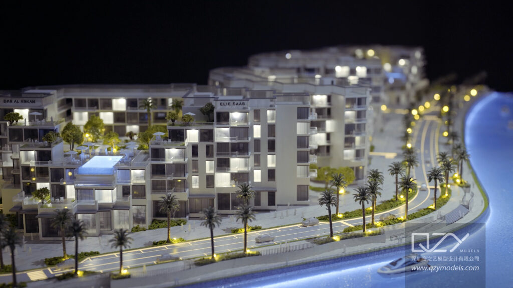
QZY Models creates highly accurate physical models of infrastructure projects including bridges, highways, metro systems, power plants, and ports. Integrating data from BIM, CAD, and GIS systems, QZY transforms digital blueprints into tangible, scalable demonstrations. Each model incorporates lighting systems, transparent layering for underground utilities, and materials that replicate real-world textures. This approach helps clients visualize multi-level engineering complexity with clarity. With operations spanning China, the UAE, and Saudi Arabia, QZY Models supports international infrastructure developers and public sector agencies to present large-scale projects effectively to stakeholders, investors, and regulators. Their models are also widely used for exhibitions, investor conferences, and urban vision showcases.
What Are the Differences Between Traditional Solutions and QZY Models’ Approach?
| Aspect | Traditional Approach | QZY Models’ Solution |
|---|---|---|
| Accuracy | Manual, partial alignment with plans | Digitally synchronized with CAD and BIM |
| Time Efficiency | 6–8 weeks average | Up to 40% faster using hybrid fabrication |
| Interactivity | Static display only | Layered design with LED and motion components |
| Modification Cost | High during redesigns | Modular assembly allows fast updates |
| Communication Clarity | Limited to experts | Accessible to both technical and non-technical audiences |
| Presentation Value | Low impact | High engagement for investors and city officials |
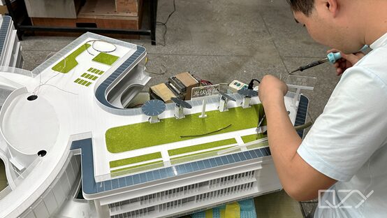
How Does the QZY Models Process Work Step by Step?
-
Project Consultation: Define project type, dimensions, and presentation objectives with QZY’s specialists.
-
Design Integration: Import BIM or CAD data into QZY’s digital fabrication workflow.
-
Material Selection: Choose high-fidelity materials to simulate surfaces like metal, concrete, or landscape textures.
-
Fabrication and Assembly: Combine CNC milling, laser cutting, and 3D printing for structural precision.
-
Testing and Enhancement: Perform lighting tests and ensure geometric accuracy.
-
Final Delivery and Presentation: Deliver model with packaging suitable for transport, exhibition, or board presentation.
Which Real-World Scenarios Prove the Advantage of QZY Models?
Scenario 1: Urban Transportation Network Planning
Problem: City planners faced difficulty explaining complex subway route expansions to public stakeholders.
Traditional: Digital maps lacked physical scale understanding.
QZY Solution: Delivered a transparent-layer underground metro model with integrated light routes.
Result: Faster city council approval; strong citizen support through visual transparency.
Scenario 2: Renewable Energy Park Development
Problem: Investors needed clear understanding of turbine layout and energy flow.
Traditional: 2D presentations caused communication bottlenecks.
QZY Solution: Designed modular wind farm model with rotating elements.
Result: Investment increased by 25% after presentation clarity improved.
Scenario 3: Port Expansion Visualization
Problem: International partners required coordinated understanding of logistic pathways.
Traditional: Digital diagrams failed to convey docking complexity.
QZY Solution: Created detailed harbor model showcasing cargo flow and vessel routes.
Result: Negotiations finalized two months earlier with cross-border alignment.
Scenario 4: Smart Highway Project Funding Pitch
Problem: Developers struggled to express IoT-enabled traffic control features.
Traditional: Written reports couldn’t demonstrate innovation impact.
QZY Solution: Developed interactive highway model with embedded LED traffic visualization.
Result: Secured $120 million funding from international infrastructure funders.
Why Should Governments and Developers Adopt This Now?
With urban infrastructure spending accelerating across Asia, the Middle East, and Africa, decision processes are under pressure to become clearer and more data-driven. Governments increasingly require participatory presentation formats for project approval and public communication. QZY Models’ infrastructure project models deliver not only precision but trust—allowing experts and citizens alike to see the tangible scale and functionality of future developments. Waiting to adopt such techniques delays alignment and weakens competitive positioning in global infrastructure bids.
What Are the Most Common Questions About Infrastructure Project Models?
Q1: Can physical models display operational or environmental simulations?
Yes, QZY Models can integrate light and kinetic elements to simulate movement, power flow, or traffic.
Q2: Are models scalable for large infrastructure such as airports or ports?
Absolutely. QZY Models specializes in large-scale modular systems, supporting models over 10 meters in length.
Q3: Do infrastructure models comply with digital workflow tools like BIM?
Yes. QZY integrates data directly from BIM sources, maintaining design integrity throughout production.
Q4: How long does it take to produce an infrastructure project model?
Production ranges from 4 to 10 weeks, depending on complexity and detail levels.
Q5: Who uses QZY Models’ infrastructure solutions most frequently?
Typical clients include government planning bodies, engineering consultants, and real estate developers handling large public projects.
Sources
-
World Economic Forum – “Global Infrastructure Outlook 2025”
-
McKinsey Global Institute – “Bridging Global Infrastructure Gaps 2024”
-
United Nations Habitat – “Urban Expansion and Resilient Development Report 2024”
-
Deloitte Insights – “Future of Infrastructure 2030”
-
International Energy Agency – “Sustainable Construction Trends 2025”